Australia is one of the world’s most recognizable countries, known for its enormous landscapes, distinctive wildlife, coastal cities, and vast outback. But what would the country look like if its familiar state and territory boundaries were replaced with an entirely different regional system?
An interesting alternative map imagines exactly that.
Instead of the traditional administrative divisions, the map presents ten colorful regions with unusual names such as Topendia, Westralia, Bassland, Goyderland, and Heartlandia. Major Australian locations, including Sydney, Melbourne, Perth, Darwin, Adelaide, and Cairns, provide geographical reference points.
The result is a creative reimagining of Australia’s geography that raises an interesting question: could the country be divided in a completely different way?
It is important to understand that this is a fictional geographical concept, not an official Australian government proposal. Nevertheless, it provides an opportunity to explore Australia’s real geography, its administrative boundaries, and the history behind its current states and territories.
1. Understanding the Alternative Map of Australia
The map divides Australia into ten differently colored areas, each with its own distinctive name.
Some names appear to draw inspiration from familiar geographical descriptions, while others are entirely imaginative.
Here is what the map displays:
Topendia
Located across the northern interior and extending toward the Top End, this purple region includes the area around Darwin and Alice Springs on the illustration.
The Top End is a familiar geographical term for the northernmost part of the Northern Territory.
Westralia
The green region occupies the southwestern part of the map, around Perth.
Its name resembles Western Australia, the country’s largest state by land area.
NW Territories
This red region covers a large section of northwestern Australia.
The name sounds like an alternative version of the Northern Territory, but it is not an official Australian jurisdiction.
Capeland
The brown region appears in the northeastern part of the map, around the Cairns area.
Its name may suggest a connection to Australia’s northern capes and coastal geography, although the image does not explain its origin.
Oceania
The blue region follows part of Australia’s eastern coastline.
Oceania is actually a much broader geographical region that includes Australia and numerous Pacific island countries and territories. It is not an Australian state or territory.
Outlandia
The large yellow region occupies much of the central and southern interior.
Its imaginative name suggests the country’s extensive inland landscapes and remote outback areas.
Heartlandia
The gray region covers a substantial part of eastern and southeastern inland Australia.
Its name suggests a central or heartland region, but it has no official administrative status.
Goyderland
The pink region appears in the southern part of the map, around Adelaide.
The name is distinctive, but the image does not establish any official connection between this fictional region and a historical boundary.
Bassland
The orange region includes Tasmania and a small section of southeastern mainland Australia.
The name may evoke Bass Strait, the stretch of water separating mainland Australia from Tasmania.
ACT
Unlike most of the other names, ACT refers to a real Australian territory: the Australian Capital Territory.
Canberra, Australia’s national capital, is located within it.
2. How Australia Is Actually Divided
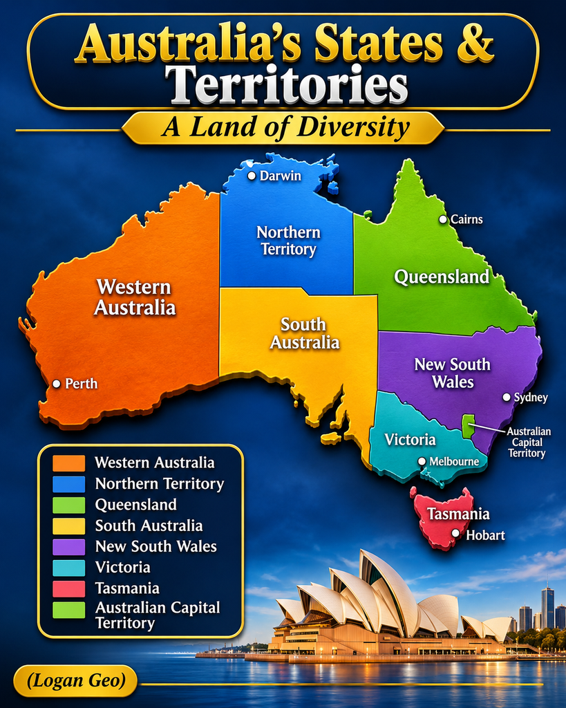
Australia’s real administrative structure is quite different from the colorful alternative map.
According to the Australian Government, the country is a federation consisting of six states and two self-governing territories. <a href=”https://www.dfat.gov.au/about-us/publications/corporate/protocol-guidelines/1-introduction-to-australia-and-its-system-of-government“> </a>
The six states are:
- New South Wales
- Victoria
- Queensland
- Western Australia
- South Australia
- Tasmania
The two mainland territories are:
- Northern Territory
- Australian Capital Territory
Each state and territory has its own government and responsibilities.
For example, New South Wales contains Sydney, Victoria contains Melbourne, Queensland contains Brisbane, Western Australia contains Perth, South Australia contains Adelaide, and Tasmania has Hobart as its capital.
The Northern Territory has Darwin as its capital, while Canberra is located in the Australian Capital Territory.
These official divisions are important for government, public services, elections, administration, and the delivery of infrastructure.
3. Why Does Australia Have Six States?
The history of Australia’s current boundaries goes back to the colonial period.
Before Federation, the Australian continent was divided into separate British colonies. Each colony developed its own government, laws, administrative arrangements, and territorial boundaries.
On 1 January 1901, the six colonies joined together to form the Commonwealth of Australia.
Rather than completely redesigning the continent’s internal boundaries, the colonies retained their existing territories and became the six states of the new federation.
This historical decision explains why Australia still has its familiar six-state structure today.
The Parliamentary Education Office provides an explanation of this process and the history of Australian Federation.
4. Could Australia Be Divided Into Different Regions?
Geographically, there are many ways to divide a large country.
A nation could be divided according to climate, population, natural landscapes, economic activity, transportation networks, or cultural characteristics.
For example, Australia has several recognizable geographical environments:
- Tropical northern regions.
- Arid central deserts.
- Temperate southeastern areas.
- Fertile agricultural regions.
- Tropical rainforests in the northeast.
- Extensive coastal environments.
A geographical map based on these characteristics would look very different from a map based on political boundaries.
The fictional regions in the illustration offer one possible creative interpretation, but their boundaries are not supported by an official administrative framework.
A real government proposal would require detailed consideration of population distribution, infrastructure, local communities, legal arrangements, and government responsibilities.
5. Why Regional Boundaries Matter
Administrative boundaries are more than lines drawn on a map.
They influence how governments organize services and make decisions.
Australia has three levels of government:
- Federal government.
- State and territory governments.
- Local government.
These levels have different responsibilities, including national affairs, education, healthcare, transport, infrastructure, and local services.
Changing the country’s state or territory structure could therefore involve major constitutional, political, financial, and administrative questions.
It would not simply mean changing the colors and names on a map.
The Parliamentary Education Office explains how Australia’s three levels of government work together.
6. What Makes Australia’s Geography So Interesting?
One reason alternative maps of Australia attract attention is the country’s extraordinary geographical diversity.
Australia covers approximately 7.7 million square kilometres and is the world’s sixth-largest country by area.
Its landscapes range from tropical coastlines and mountainous regions to enormous deserts and agricultural plains.
The country’s population is also distributed unevenly. Large metropolitan areas are concentrated around the coast, while extensive inland areas have much lower population densities.
Cities such as Sydney, Melbourne, Brisbane, Perth, and Adelaide are important population and economic centers.
Meanwhile, remote regions contain distinctive ecosystems, Indigenous cultural landscapes, mining operations, pastoral properties, and protected natural environments.
This combination of large distances and diverse landscapes makes Australia particularly interesting from a geographical perspective.
7. Frequently Asked Questions
Is Australia officially divided into ten regions?
No. Australia has six states and two self-governing mainland territories. The ten names shown in the image represent a fictional alternative map.
What is Topendia?
Topendia is a fictional regional name used in the illustration. Australia’s real Top End is a geographical area in the northern part of the Northern Territory.
Is Westralia an official Australian state?
No. Western Australia is the official state name. Westralia is the alternative name displayed on this map.
What is Bassland supposed to represent?
The orange region appears to include Tasmania and part of southeastern mainland Australia. Its name may reference Bass Strait, which separates Tasmania from mainland Australia.
Why does Australia have six states?
The six states originated as separate British colonies. They joined together to form the Commonwealth of Australia in 1901 while retaining their existing boundaries.
Conclusion: One Country, Many Ways to Imagine Its Geography
Australia’s real geographical and political divisions have developed through centuries of history, settlement, and government decisions.
The alternative map offers a creative way to imagine a different arrangement, with ten colorful regions and unusual names replacing the familiar state and territory labels.
Although names such as Topendia, Westralia, Bassland, and Heartlandia are not official administrative divisions, they make the illustration an interesting conversation starter for geography enthusiasts.
It also reminds us that maps are not simply pictures of countries. They can represent political decisions, historical events, cultural identities, and different ways of understanding the world.
If Australia could be divided into ten new regions, which name would you keep, and what would you call the region where you live?