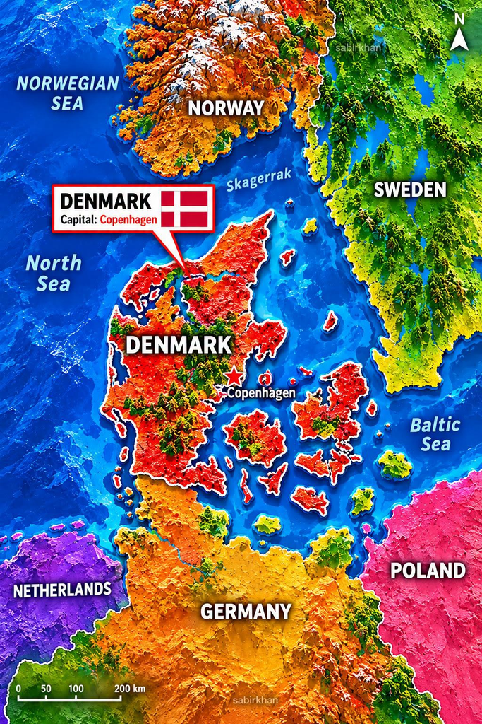
Denmark is one of Northern Europe’s most interesting countries to explore on a map. Its distinctive shape, scattered islands, and location between the North Sea and the Baltic Sea make it stand out from many other European nations.
As the colorful relief map illustrates, Denmark lies south of Norway, southwest of Sweden, and north of Germany. Its geography is closely connected to the surrounding waterways, while its islands create a landscape that looks more complicated than the country’s relatively small size might suggest.
But what makes Denmark’s geography so distinctive? Understanding its main land areas, neighboring countries, and capital city reveals why this small Scandinavian country occupies such an interesting position in Europe.
Where Is Denmark Located?
Denmark is situated in Northern Europe and is commonly grouped with the Scandinavian countries. It shares a land border with Germany to the south, while Sweden lies across the water to the east and Norway is located farther north.
The country occupies an important geographic position between the North Sea and the Baltic Sea. This location places Denmark close to mainland Europe and the Scandinavian Peninsula.
According to Denmark’s official tourism information, the country consists of the Jutland Peninsula and more than 400 islands. Its geography is characterized by extensive coastlines, relatively low terrain, and numerous waterways. Source: VisitDenmark
Unlike countries dominated by high mountains, Denmark is mostly flat or gently rolling. Its landscape includes agricultural fields, sandy beaches, coastal dunes, forests, and small hills.
This combination of land and water gives Denmark a distinctive appearance when viewed from above.
Why Does Denmark Have So Many Islands?
One of the most noticeable features of the map is the collection of Danish islands scattered across the surrounding waters.
Denmark includes hundreds of islands, although the exact number depends on how islands are defined and counted. Some are inhabited communities with towns and transport connections, while others are small and uninhabited.
Three particularly important islands or land areas help explain Denmark’s geography.
1. Jutland: Denmark’s Connection to Mainland Europe
Jutland is the large peninsula extending northward from Germany. It forms the western portion of Denmark and provides the country’s direct land connection to mainland Europe.
The peninsula is known for its open countryside, beaches, coastal landscapes, and historic settlements.
Because Jutland is connected to Germany, travelers can move between Denmark and continental Europe by road or rail. Major cities such as Aarhus and Aalborg are located in this part of the country.
Jutland is therefore an essential part of Denmark’s geography, connecting the country’s island regions with mainland Europe.
2. Zealand: Home to Copenhagen
Zealand, also known as Sjælland in Danish, is Denmark’s largest island by area and one of its most important population centers.
The capital, Copenhagen, is located on Zealand’s eastern side, near the water separating Denmark from Sweden.
Copenhagen is internationally known for its historic architecture, waterfront neighborhoods, cycling culture, museums, and modern urban design.
Zealand’s position also makes it important for transportation. Bridges, roads, railways, and ferry routes connect different parts of Denmark, while the Øresund Bridge provides a direct connection between the Copenhagen area and Malmö in Sweden.
This connection helps illustrate how geography can shape everyday travel and economic relationships between neighboring countries.
3. Funen: The Island Between Major Regions
Funen, called Fyn in Danish, lies between Jutland and Zealand. It is another major island in the Danish landscape.
The city of Odense, associated with the famous Danish author Hans Christian Andersen, is located on Funen.
Funen helps connect Denmark’s western and eastern regions. Bridges and transport links make travel between the major parts of the country easier, despite the water separating many land areas.
Together, Jutland, Zealand, and Funen provide a useful starting point for understanding Denmark’s unusual shape.
The North Sea, Baltic Sea, and Skagerrak
The surrounding seas are among the most important features of Denmark’s location.
The North Sea lies west of Denmark, beside the western coast of Jutland. This coastline includes long beaches, sandy dunes, and exposed stretches of shore shaped by wind and waves.
The Baltic Sea lies to the east and southeast, connecting Denmark with a wider region that includes Sweden, Germany, Poland, and other countries bordering the Baltic.
Between Denmark and southern Norway lies the Skagerrak, a body of water that also borders parts of Sweden. The nearby Kattegat connects this maritime region with the waters farther south.
These waterways are more than labels on a map. They help explain Denmark’s historical importance as a maritime nation and its connections with other parts of Northern Europe.
For centuries, the surrounding seas have influenced shipping, fishing, trade, settlement, and travel. Today, the same geographic position remains relevant to transportation and regional cooperation.
Why Is Denmark’s Geography Important?
Denmark’s position between mainland Europe and Scandinavia has helped make it an important crossroads for movement between neighboring regions.
Its islands and coastlines have influenced where communities developed and how people traveled between them. Ports, bridges, ferries, and rail connections help link places that are separated by water.
The Øresund Bridge is a particularly clear example. It connects the Copenhagen area with Malmö in southern Sweden, creating a direct transport route between the two countries.
Denmark’s coastline also influences its natural environment. Coastal dunes, beaches, wetlands, and low-lying landscapes are important parts of its scenery.
For visitors, this geography creates opportunities to explore historic cities, seaside towns, countryside, and islands within a relatively compact country.
For map enthusiasts, it also provides a useful example of how political borders, physical geography, and transportation networks interact.
Is Denmark the Same as the Kingdom of Denmark?
An important distinction is often overlooked when looking at maps of Northern Europe.
Denmark itself is a relatively small European country. The wider Kingdom of Denmark also includes Greenland and the Faroe Islands, which have extensive self-government.
Greenland is a vast island located in the North Atlantic and Arctic regions, while the Faroe Islands form an archipelago in the North Atlantic.
Neither territory appears in the main geographic area shown in the uploaded image.
This distinction matters because a map focused on Denmark’s European mainland and islands does not represent the entire geographic extent of the Kingdom of Denmark.
It also explains why sources sometimes give different figures for the kingdom’s total area: the numbers may refer either to Denmark proper or to the wider kingdom.
What the Colorful Map Does—and Does Not—Show
The uploaded map uses bright red, orange, green, and purple colors to separate Denmark from neighboring countries.
Its three-dimensional appearance makes coastlines and landforms easy to distinguish visually. The labels also help viewers identify nearby countries and surrounding waters.
However, the colors should not be interpreted as actual ground colors, political data, or precise elevation measurements. The image is a stylized illustration rather than a conventional reference map.
Its scale bar provides a general sense of distance, but the image should not replace a reliable geographic map when exact measurements, borders, or navigation details are needed.
The most useful lesson from the image is the overall arrangement of land and water: Denmark’s islands, its connection to Germany, and its proximity to Sweden and Norway.
Frequently Asked Questions
1. What is the capital of Denmark?
Copenhagen is the capital of Denmark. It is located on the island of Zealand, near the Øresund Strait and the Swedish city of Malmö.
2. How many islands does Denmark have?
Denmark has more than 400 islands. Counts vary by source and by the criteria used to define an island; many of the islands are uninhabited.
3. Which countries border Denmark?
Denmark shares a land border with Germany. Sweden lies across the water to the east, and Norway is located to the north across the Skagerrak region.
4. Which seas surround Denmark?
The North Sea lies to the west, while the Baltic Sea lies to the east and southeast. The Skagerrak and Kattegat are also important waterways in the surrounding region.
5. Is Greenland part of Denmark?
Greenland is part of the wider Kingdom of Denmark and has extensive self-government. It is geographically separate from Denmark in Europe and is not shown on the uploaded map.
Conclusion
Denmark’s map reveals much more than the outline of a small Northern European country. Its Jutland Peninsula, hundreds of islands, and capital on Zealand create a distinctive geographic pattern shaped by the surrounding seas.
Its location between Germany, Sweden, Norway, the North Sea, and the Baltic Sea helps explain its longstanding connections with neighboring countries.
The next time you look at a map of Denmark, pay attention to the waterways as well as the land. They are essential to understanding how the country’s geography fits together—and why this corner of Northern Europe is so fascinating.