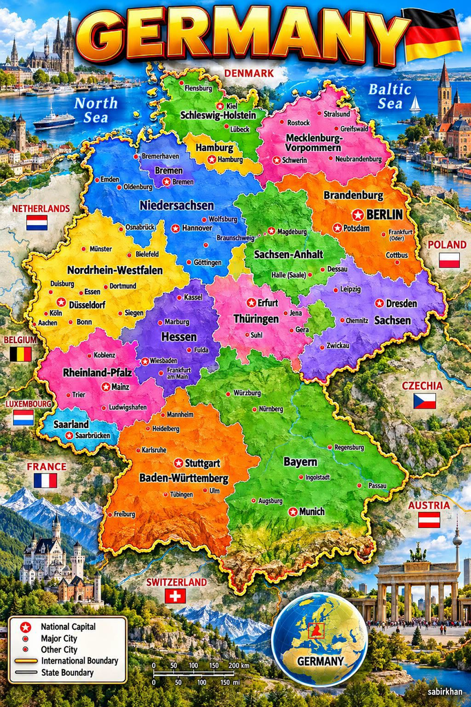
Germany is one of Europe’s most recognizable countries, but its geography offers much more than a single capital city or famous landmarks. Its colorful map reveals a country divided into 16 federal states, each with its own administrative structure, regional character, and important cities.
From Hamburg’s northern waterways to Munich’s location near the Bavarian Alps, Germany’s regions cover a wide variety of landscapes and urban environments. Berlin stands out as the national capital, while other cities serve as major centers of industry, culture, education, and commerce.
Understanding Germany’s map is a useful starting point for anyone interested in European geography, planning a trip, or learning how the country is organized.
Where Is Germany Located?
Germany lies in Central Europe and shares land borders with nine countries: Denmark, Poland, Czechia, Austria, Switzerland, France, Luxembourg, Belgium, and the Netherlands. This central position has helped make Germany an important crossroads for European travel, trade, and cultural exchange.
The North Sea and Baltic Sea border Germany in the north, while the Alps extend along part of its southern border with Austria and Switzerland.
According to Germany’s official tourism information, the country’s landscape includes coastal areas, agricultural plains, forests, rivers, lakes, uplands, and mountains.
These differences are visible on the map. Northern Germany is generally lower and flatter, while southern regions include higher terrain and Alpine scenery.
For travelers, this variety means that a journey through Germany can include seaside towns, historic cities, river valleys, countryside, and mountain landscapes.
Why Is Germany Divided Into 16 States?
Germany is a federal republic made up of 16 constituent states, known in German as Bundesländer or Länder. The federal government and the state governments have different responsibilities under Germany’s constitutional system.
Each state has its own institutions and areas of authority. These arrangements allow regional governments to make decisions on matters assigned to them while remaining part of the same country.
Germany’s 16 states are:
- Baden-Württemberg
- Bavaria
- Berlin
- Brandenburg
- Bremen
- Hamburg
- Hesse
- Mecklenburg-Western Pomerania
- Lower Saxony
- North Rhine-Westphalia
- Rhineland-Palatinate
- Saarland
- Saxony
- Saxony-Anhalt
- Schleswig-Holstein
- Thuringia
The country’s modern federal structure took shape after the Second World War. Following decades of division between East and West Germany, reunification took place on October 3, 1990.
Today, the 16-state system is an important part of Germany’s political organization.
Source: German Federal Returning Officer — State Elections.
Berlin, Hamburg, and Bremen: Germany’s Three City-States
One particularly interesting feature of Germany’s map is that three of its federal states are also city-states.
Berlin: The National Capital
Berlin is both a city and one of Germany’s 16 federal states. It is the country’s national capital and an important center for government, culture, education, and tourism.
Visitors recognize Berlin for landmarks such as the Brandenburg Gate, the Reichstag building, and the remains of the Berlin Wall.
Its location in northeastern Germany also helps explain why the neighboring state of Brandenburg surrounds it.
Hamburg: A Major Northern Port
Hamburg is another city-state, situated in northern Germany along the Elbe River. It is internationally known for its port, maritime history, warehouses, and lively cultural districts.
Although Hamburg is not directly on the open sea, its river connection gives it an important maritime role.
Bremen: A Smaller City-State
Bremen is Germany’s third city-state. The state consists of the city of Bremen and the separate coastal city of Bremerhaven.
Its history is closely associated with trade and shipping. On a map, Bremen is surrounded by Lower Saxony, making it a useful example of how Germany’s state boundaries do not always follow the outlines of large continuous regions.
Exploring Germany From North to South
Germany’s federal states can be easier to understand when grouped by their general geographic location.
Northern Germany: Coasts and Maritime Cities
Schleswig-Holstein, Mecklenburg-Western Pomerania, and Lower Saxony occupy large parts of northern Germany.
Schleswig-Holstein lies between the North Sea and Baltic Sea. Its coastline, beaches, and maritime towns make it a distinctive part of the country.
Mecklenburg-Western Pomerania, to the northeast, is known for its Baltic coastline, islands, lakes, and historic towns.
Lower Saxony stretches across a large area of northwestern Germany, with agricultural land, coastal areas, and cities such as Hanover.
These northern regions illustrate Germany’s close relationship with the sea.
Central Germany: Forests, Historic Towns, and Industry
Central Germany includes states such as Hesse, Thuringia, Saxony-Anhalt, and parts of Saxony and Rhineland-Palatinate.
Frankfurt am Main, located in Hesse, is a major financial center with an international airport and a distinctive skyline.
Thuringia is known for forested landscapes and historic towns, while Saxony-Anhalt contains important cultural and historical sites.
Dresden, the capital of Saxony, is particularly well known for its architecture and cultural heritage.
Central Germany’s combination of cities, forests, and historic settlements makes it a diverse region to explore.
Western Germany: Major Cities and Economic Centers
North Rhine-Westphalia is Germany’s most populous federal state. It includes major cities such as Cologne, Düsseldorf, Dortmund, and Essen.
The region developed a strong industrial heritage, particularly around the Ruhr area, which was historically associated with coal mining and steel production. Today, it also contains universities, cultural institutions, technology businesses, and major urban centers.
Rhineland-Palatinate and Saarland lie farther southwest, near France, Luxembourg, and Belgium.
The Rhine River, vineyards, historic towns, and castles are important features of parts of this region.
Southern Germany: Bavaria and Baden-Württemberg
Southern Germany includes Bavaria and Baden-Württemberg, two states associated with strong regional identities, major industries, and attractive landscapes.
Bavaria, known in German as Bayern, is Germany’s largest state by area. Its capital, Munich, is famous for museums, architecture, and Oktoberfest. The state’s southern reaches extend into the foothills of the Alps.
Baden-Württemberg borders France and Switzerland. Stuttgart, its capital, is closely associated with automotive engineering and manufacturing.
The region also features forests, lakes, historic towns, and scenic countryside.
These southern states demonstrate how Germany’s geography changes as the landscape rises toward the Alps.
Which Countries Border Germany?
Germany shares land borders with nine neighboring countries, giving it more land-border neighbors than any other European country.
The Netherlands, Belgium, Luxembourg, and France lie to the west. Denmark is to the north, while Poland and Czechia lie to the east. Austria and Switzerland border Germany in the south.
These connections make Germany a central destination for cross-border rail services, road travel, business, and tourism.
For visitors, the country’s location makes it possible to combine a German city break with trips to neighboring European destinations.
How to Read the Map Correctly
The colorful map uses different shades to distinguish Germany’s federal states. It also marks cities and identifies the national capital using a special symbol.
However, not every city marked is a state capital. Berlin is the national capital, while states such as Bavaria, Hesse, and Saxony have their own capitals: Munich, Wiesbaden, and Dresden, respectively.
The image is a stylized educational illustration. Its labels and decorative background should not replace an official map when checking exact boundaries, distances, or locations.
For accurate geographic information, consult Germany Travel or official government resources.
Frequently Asked Questions
1. How many states does Germany have?
Germany has 16 federal states, each with its own regional institutions and responsibilities.
2. What is the capital of Germany?
Berlin is Germany’s national capital. It is also one of the country’s 16 federal states.
3. Which is Germany’s largest state?
Bavaria is the largest German federal state by area. North Rhine-Westphalia is the most populous.
4. Which countries share a border with Germany?
Germany borders Denmark, Poland, Czechia, Austria, Switzerland, France, Luxembourg, Belgium, and the Netherlands.
5. Are Berlin, Hamburg, and Bremen separate states?
Yes. All three are city-states, meaning each is both a city and a federal state within Germany.
Conclusion
Germany’s map tells the story of a country with varied landscapes, major urban centers, and a distinctive federal structure.
Its 16 states range from northern coastal regions to the mountains of the south. Berlin serves as the national capital, while cities such as Hamburg, Frankfurt, Cologne, Dresden, Stuttgart, and Munich play important regional roles.
Whether you’re studying European geography or planning a future trip, learning how Germany’s states fit together makes the country easier to understand.
Look beyond the national outline, and the map becomes a guide to Germany’s regional diversity, history, and connections with the rest of Europe.