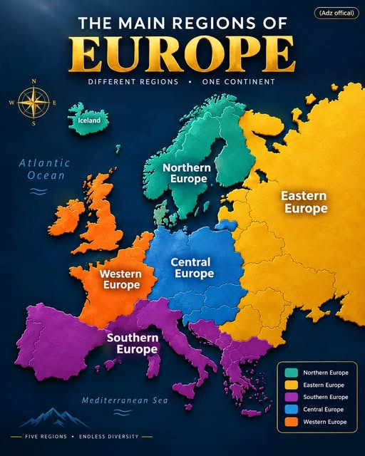
Europe is a continent of remarkable geographical and cultural diversity. From the fjords and forests of the north to the Mediterranean coastlines of the south, its landscapes, languages, traditions, and histories vary greatly across relatively short distances.
One useful way to understand this diversity is to divide Europe into five broad regions: Northern Europe, Western Europe, Central Europe, Eastern Europe, and Southern Europe. A color-coded map makes these areas easier to visualize, but the boundaries are not universally agreed upon. Different maps, educational systems, and statistical organizations may classify certain countries differently.
Here is a closer look at Europe’s five regions, their defining characteristics, and what makes each part of the continent distinctive.
1. Northern Europe: Fjords, Forests, and Nordic Landscapes
Northern Europe is associated with dramatic natural scenery, cool climates, extensive forests, and long coastlines. The Nordic countries—Denmark, Finland, Iceland, Norway, and Sweden—are especially well known for their distinctive landscapes and regional connections.
Norway features deep fjords carved by glaciers, while Sweden and Finland contain extensive forests and thousands of lakes. Iceland is famous for its volcanic terrain, glaciers, waterfalls, and geothermal activity. Denmark, by comparison, has a generally flatter landscape and a long maritime history.
The Baltic states—Estonia, Latvia, and Lithuania—are also grouped with Northern Europe in the United Nations’ statistical classification. However, some educational maps place them closer to Eastern or Central Europe.
The United Kingdom and Ireland are sometimes included in broader definitions of Northern Europe, although they are also frequently described as Northwestern European countries.
Northern Europe is therefore more than a simple climatic category. It combines several countries with different languages and histories while sharing important connections through trade, maritime activity, and regional cooperation.
2. Western Europe: Historic Cities and International Connections
Western Europe is often associated with historic urban centers, influential cultural institutions, major economic hubs, and centuries of international trade.
France, Belgium, the Netherlands, and Luxembourg are commonly associated with Western Europe. Germany and Switzerland are also included in Western European groupings in some classifications, while other maps place them in Central Europe.
The region contains a wide range of landscapes. The Netherlands is known for its low-lying terrain, canals, and extensive coastal engineering. France includes Atlantic coastlines, Mediterranean shores, fertile agricultural areas, and the Alpine mountains. Switzerland is famous for its mountainous scenery and Alpine valleys.
Western Europe’s history has been shaped by changing kingdoms, trade networks, industrialization, artistic movements, and political cooperation. Cities such as Paris, Amsterdam, Brussels, and Geneva have developed different roles in culture, commerce, diplomacy, and international affairs.
Despite their close connections, Western European countries are not culturally identical. Their languages, regional traditions, political histories, and local identities remain distinct.
3. Central Europe: A Crossroads of Cultures
Central Europe occupies a broad area between the continent’s western and eastern regions. Its location has helped make it an important crossroads for trade, migration, cultural exchange, and political change.
Countries frequently associated with Central Europe include Austria, Czechia, Hungary, Poland, Slovakia, and Switzerland. Germany and Slovenia may also be included, depending on the definition being used.
The region’s geography is varied. The Alps dominate parts of Austria and Switzerland, while the Carpathian Mountains extend into neighboring areas. Major rivers, including the Danube, connect several Central European countries and have historically supported transport and commerce.
Central European cities reflect layers of architectural and historical influence. Prague is known for its historic center, Vienna for its imperial heritage and musical traditions, and Budapest for its position along the Danube.
The region has experienced major political transformations, including the rise and fall of empires, changing national borders, and the division of Europe during the Cold War. These developments continue to influence how Central Europe is understood today.
Central Europe is a useful geographical concept, but its precise boundaries can shift according to whether a map emphasizes physical geography, historical experience, culture, or contemporary politics.
4. Eastern Europe: Vast Landscapes and Diverse Histories
Eastern Europe covers a large area stretching toward the eastern edges of the continent. Its landscapes include extensive plains, river basins, forests, agricultural regions, and major urban centers.
Belarus, Moldova, Ukraine, and European Russia are commonly associated with Eastern Europe, although regional classifications differ. Some maps also place countries such as Poland, Hungary, Romania, Bulgaria, and the Baltic states in Eastern Europe, while others group them into Central, Southeastern, or Northern Europe.
Ukraine contains broad agricultural plains and major river systems, including the Dnipro River. Belarus is known for its forests and wetlands, while Moldova has a landscape shaped by rolling hills and agricultural production.
The region’s history includes medieval principalities, expanding empires, changing national borders, and the political divisions of the twentieth century. The Soviet period and its aftermath have had a major influence on the modern histories of several Eastern European countries, though each country has its own distinct experience.
It is important not to treat Eastern Europe as a single culture or political identity. Languages, religions, historical traditions, and contemporary circumstances vary considerably throughout the region.
The term is most useful when its meaning is clearly defined rather than assumed to describe every country in the same way.
5. Southern Europe: Mediterranean Coasts and Ancient Heritage
Southern Europe is strongly associated with the Mediterranean Sea, warm summers in many coastal areas, historic settlements, and cultural traditions shaped by centuries of travel and trade.
Italy, Spain, Portugal, and Greece are among the countries most commonly associated with Southern Europe. The region also includes several Balkan countries and smaller states, depending on the classification.
Italy’s landscape ranges from the Alps in the north to the Mediterranean islands in the south. Spain contains plateaus, mountain ranges, Atlantic coastlines, and Mediterranean shores. Portugal faces the Atlantic Ocean, while Greece is distinguished by its mountainous mainland and numerous islands.
Southern Europe played a central role in several important historical periods. Ancient Greek civilization influenced philosophy, politics, art, and architecture. The Roman world left a lasting legacy across much of Europe and the Mediterranean. Later centuries brought maritime exploration, commercial networks, and cultural exchange across the region.
Food, architecture, music, festivals, and local traditions are important parts of Southern Europe’s identity, but the region is highly diverse. The experiences of Portugal, Italy, Greece, and the Balkans cannot be reduced to one shared lifestyle.
Its combination of coastlines, mountains, islands, and historic cities makes Southern Europe one of the continent’s most geographically varied areas.
Why Do Maps Divide Europe Differently?
The five-region map is a helpful learning tool, but it is not the only accepted system.
The United Nations Statistics Division’s M49 standard uses four European subregions for statistical purposes: Eastern Europe, Northern Europe, Southern Europe, and Western Europe. It does not use Central Europe as a separate subregion in that system.
The UN explains that its geographical groupings are designed for statistical use rather than to establish political or cultural affiliations. Other maps may use five regions to make Central Europe’s distinct position easier to understand.
Countries near regional boundaries are particularly likely to be classified differently. Poland, Germany, Slovenia, Romania, and the Baltic states are examples of countries whose regional descriptions can vary with the source.
These differences do not necessarily mean that one map is incorrect. They often reflect different goals, such as teaching physical geography, studying cultural history, or organizing international statistics.
For this reason, it is best to read a regional map as a framework for understanding Europe rather than as a definitive statement about national identity.
Frequently Asked Questions
How many regions does Europe have?
There is no single universally accepted number. Five-region maps commonly show Northern, Western, Central, Eastern, and Southern Europe. The United Nations’ M49 statistical system divides Europe into four subregions.
Which countries belong to Central Europe?
Austria, Czechia, Hungary, Poland, and Slovakia are frequently included. Germany, Switzerland, and Slovenia may also be classified as Central European, depending on the source.
Are the five regions separated by official borders?
Not generally. Countries have internationally recognized national boundaries, but the boundaries between broad cultural and geographical regions are usually interpretive rather than official international borders.
Is Russia part of Europe?
Russia spans both Europe and Asia. Its western territory lies in Europe, while much of its landmass extends across northern Asia. Maps may display only its European portion or show a larger area for geographical context.
Why is regional geography useful?
Regional geography helps people organize information about landscapes, climates, languages, history, economies, and cultural connections. It provides a useful starting point for understanding differences across a continent.
Conclusion: Five Regions, One Diverse Continent
Europe’s five broad regions offer a simple way to explore a continent shaped by geography, history, migration, trade, and cultural exchange. Northern Europe’s Nordic landscapes, Western Europe’s historic cities, Central Europe’s crossroads, Eastern Europe’s expansive territories, and Southern Europe’s Mediterranean environments each contribute to Europe’s diversity.
Yet the map is only the beginning. Regional classifications vary, and countries often share connections that cross the lines drawn on a page.
Understanding these distinctions makes European geography more interesting—and reminds us that a continent’s identity cannot always be captured by a single map.
Reference: United Nations Statistics Division, Standard Country or Area Codes for Statistical Use (M49): https://unstats.un.org/unsd/methodology/m49/overview/