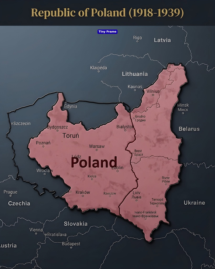
Imagine looking at a map of Europe from the 1930s. Poland would look noticeably different from the country we recognize today. Its territory stretched much farther east, including cities that are now located in Ukraine, Lithuania and Belarus.
This was the Second Polish Republic, an independent state that existed from 1918 until the outbreak of World War II in 1939.
The map of this country tells an extraordinary story of independence, territorial disputes, political challenges and dramatic changes in European history. It also helps explain why modern Poland has different borders from the country that existed before World War II.
So how did Poland regain its independence, what territories did it control, and what happened to its eastern lands?
1. Poland returned to the European map in 1918
For more than a century, Poland had disappeared as an independent country.
Between 1772 and 1795, three neighboring powers—Russia, Prussia and Austria—partitioned Polish territory in three stages. The final partition in 1795 ended the existence of the Polish state as an independent political entity.
Despite losing their country, Polish communities continued preserving their language, traditions and national identity.
The opportunity for independence arrived during World War I. Russia experienced revolution, while Germany and Austria-Hungary were defeated or weakened by the end of the conflict.
On November 11, 1918, Poland regained its independence after 123 years of partition. Józef Piłsudski became one of the central figures in rebuilding the new state. Gov.pl website+1
However, independence did not immediately establish Poland’s final borders. The new country still had to determine its territory through military conflicts, negotiations and international agreements.
2. How Poland established its borders
Between 1918 and 1923, Poland experienced several conflicts that helped determine its geographical shape.
Its borders were not simply inherited from an earlier political map. They emerged through a complicated combination of diplomacy, warfare and local political movements.
The western border
Poland’s western territories were influenced by the Treaty of Versailles, signed in 1919.
The Greater Poland Uprising helped secure much of the region around Poznań for Poland. Further territorial decisions followed the Silesian uprisings and international arrangements.
Poland also received access to the Baltic Sea through the Polish Corridor. However, the important port city of Danzig, now Gdańsk, became a separate Free City under League of Nations protection rather than being incorporated directly into Poland.
This arrangement later became one of the major sources of tension between Poland and Germany. Institute of National Remembrance+1
The eastern border
The eastern border was even more complicated.
Poland fought a major war against Bolshevik Russia between 1919 and 1921. The conflict included the famous Battle of Warsaw in August 1920, when Polish forces stopped a major Soviet advance.
The war ended with the Treaty of Riga, signed on March 18, 1921.
This agreement established the Polish-Soviet border and brought an end to the conflict. It also helped define the eastern extent of the Second Polish Republic. Gov.pl website+1
3. The eastern territories that are now part of other countries
One of the most interesting features of the historical map is how far Poland extended eastward.
Several territories that belonged to interwar Poland are now located in neighboring countries.
Львов развитие – как изменился город – Финансы – Финансы
High Angle View Of Townscape Against Sky During Sunset
Belarus, The Church, 2K, Grodno Hd Wallpaper
9
Lwów – now Lviv, Ukraine
Lwów was one of the most important cities in eastern Poland.
It was a major center of education, culture, trade and political activity. The city had a complex population that included Poles, Ukrainians and Jews, among others.
Following World War II, Lwów became part of Soviet Ukraine. Today, it is known as Lviv and is one of Ukraine’s major western cities.
Wilno – now Vilnius, Lithuania
Wilno, today called Vilnius, was another important city inside interwar Poland.
Its incorporation was controversial. In October 1920, General Lucjan Żeligowski’s forces captured the city in an operation associated with Józef Piłsudski’s eastern policy.
The area subsequently became part of Poland in 1922. Lithuania strongly rejected the arrangement, and relations between the two countries remained strained. International recognition of the eastern Polish frontier followed in 1923. walkaogranice.ipn.gov.pl+2
Today, Vilnius is the capital of independent Lithuania.
Eastern Galicia and western Belarus
Other areas shown on the map included territories that are now within Ukraine and Belarus.
Cities such as Białystok, Brest and other regional centers played important roles in the political and economic geography of the Second Polish Republic.
The eastern regions were culturally diverse, with different languages, religions and communities living within the same state.
This diversity was one of the defining characteristics of interwar Poland.
4. What was life like inside the Second Polish Republic?
The Second Polish Republic was not simply a country defined by its borders. It was also a society undergoing major political, economic and cultural changes.
After independence, the new government faced the difficult task of bringing together territories that had previously been administered by three different empires.
Railway systems, legal institutions, currencies, education systems and administrative structures had to be integrated.
Warsaw became the political center, while cities such as Kraków, Poznań, Lwów and Wilno remained important regional centers.
Poland also had a large rural population. According to historical census information, its population reached approximately 31.9 million in 1931 and was estimated at around 35 million by 1939. World Bank+1
The country was also home to significant Polish, Jewish, Ukrainian, Belarusian, German and other communities.
This made the Second Polish Republic a multicultural state, although ethnic and political tensions were also important features of its history.
5. Gdynia became an important Polish port city
Another interesting feature of the interwar map is Gdynia, located on the Baltic coast.
Because Danzig was a separate Free City, Poland wanted a major seaport under its own control.
The government therefore supported the development of Gdynia, which transformed from a relatively small coastal settlement into a modern port city.
File:Gdynia Dworzec Morski.jpg – Wikimedia Commons
During the interwar period, Gdynia became an important center for maritime trade and shipping.
Its development represented Poland’s efforts to strengthen its economy and secure independent access to international maritime commerce.
Today, Gdynia remains an important port city and part of the Tricity metropolitan area alongside Gdańsk and Sopot.
6. Why did Poland disappear from the map again in 1939?
The Second Polish Republic’s existence came to a dramatic end in September 1939.
On September 1, Nazi Germany invaded Poland from the west, beginning World War II in Europe.
Polish forces resisted the invasion, but Germany possessed significant military advantages.
Then, on September 17, the Soviet Union invaded Poland from the east under the terms of the secret protocol of the 1939 Molotov–Ribbentrop Pact between Nazi Germany and the Soviet Union.
Poland was attacked from two directions and eventually occupied and divided between the two invading powers. Research Guides at Library of Congress+1
The country’s government continued operating in exile, and Polish forces continued fighting alongside the Allied powers.
However, the independent state shown on the historical map no longer controlled its territory.
7. How Poland’s borders changed after World War II
The end of World War II brought another major geographical transformation.
Poland’s eastern territories were incorporated into the Soviet Union, while the country received former German territories farther west.
As a result, Poland shifted significantly westward.
Cities such as Lwów and Wilno were no longer part of Poland. Meanwhile, former German territories, including areas around Wrocław and Szczecin, became part of post-war Poland.
These changes fundamentally transformed the country’s geographical position, population and political landscape.
The modern Polish map is therefore very different from the one shown in the image.
Frequently Asked Questions
1. What was the Second Polish Republic?
It was the independent Polish state established in 1918 after 123 years of partition. It existed until the German and Soviet invasions in 1939.
2. Was Lviv part of Poland before World War II?
Yes. Lviv, then known as Lwów, was part of the Second Polish Republic. Following World War II, it became part of Soviet Ukraine and is now in independent Ukraine.
3. Was Vilnius part of Poland in the 1930s?
Yes. Vilnius, then called Wilno in Polish, was incorporated into Poland in 1922 and remained within its borders until World War II.
4. Why did Poland’s borders move west after World War II?
Post-war territorial agreements transferred Poland’s former eastern territories to the Soviet Union while assigning former German territories to Poland. This created a substantial westward shift.
5. When did the Second Polish Republic end?
Its territory was invaded by Germany on September 1, 1939, and by the Soviet Union on September 17, 1939. The country was subsequently occupied and divided.
Conclusion
The map of the Second Polish Republic is more than an illustration of old borders. It represents a remarkable chapter in European history.
After disappearing from the political map in 1795, Poland regained independence in 1918 and spent the following years rebuilding its institutions and establishing its territory.
For two decades, cities such as Warsaw, Lwów, Wilno and Kraków belonged to one independent Polish state.
But the invasions of 1939 changed everything. The Second Polish Republic disappeared, and the borders that emerged after World War II created a very different Poland.
Looking at this historical map helps us understand how dramatically European geography can change within a single generation.
G. SEO optimization
1. SEO title
The Poland That Disappeared in 1939: Historical Map Explained
2. Meta description
Explore Poland’s 1918–1939 borders, its lost eastern territories, historic cities and the events of World War II that changed Europe’s map forever.
3. Suggested URL slug
second-polish-republic-map-1918-1939
4. Primary focus keyword
Second Polish Republic
5. Secondary keywords
- Poland historical map
- Poland borders 1918–1939
- Pre-war Poland
- Poland before World War II
- Second Polish Republic map
- Lost territories of Poland
- Polish history
- Lwów history
- Wilno history
- Poland 1939 borders
6. Long-tail search phrases
- What did Poland look like before World War II?
- Why were Poland’s borders different in 1939?
- Which countries once belonged to Poland?
- Was Lviv part of Poland before World War II?
- Was Vilnius part of Poland in 1939?
- How did Poland regain independence in 1918?
- Why did Poland’s borders move west after World War II?
- What happened to Poland in September 1939?
7. Suggested article category
History & Geography
8. Relevant article tags
Second Polish Republic, Poland, European History, Historical Maps, World War II, 1918 History, 1939 History, Eastern Europe, Polish Borders, Geography.
9. Suggested image alt text
Historical map of the Second Polish Republic showing Poland's borders between 1918 and 1939, including Warsaw, Lwów, Wilno, Kraków and surrounding European countries.
10. Suggested internal links
- How Europe Changed After World War II —
[INTERNAL LINK 1] - The History of the Polish-Lithuanian Commonwealth —
[INTERNAL LINK 2] - How World War II Changed Europe’s Borders —
[INTERNAL LINK 3]
Recommended authoritative external sources
These are useful sources to link within the article:
- Poland’s Independence – Polish Ministry of Foreign Affairs
- Brief History of Poland – Institute of National Remembrance
- The Treaty of Riga – Polish Ministry of Foreign Affairs
- A Brief Timeline of Modern Polish History – Library of Congress
- The Incorporation of Vilnius into Poland – Institute of National Remembrance
H. Final quality check
Image analysis
Passed
Correctly identifies the Second Polish Republic and its historical geography.
10 Facebook titles
Passed
All titles create genuine historical curiosity.
Facebook caption
Passed
Accurately represents the article and encourages readers to visit the first comment.
Historical accuracy
Verified
Uses historical and government sources for independence, borders, Vilnius, the Treaty of Riga and the 1939 invasions.
Article quality
Passed
Original explanatory writing, historical background, relevant examples and five FAQs.
SEO optimization
Passed
Includes all requested SEO elements.
Important publishing note: The map is a useful representation of interwar Poland, but some neighboring labels use modern country names. For historical accuracy, Czechoslovakia should be used instead of Czechia and Slovakia when describing the 1930s. Also, the map’s eastern territories should not be confused with today’s international borders.
My recommendation: Publish with “The Poland That Disappeared in 1939”. It is a strong match for the historical map and gives readers a genuine reason to discover the story behind it.