Today, Australia is instantly recognizable on a world map. But European maps from several centuries ago looked very different. Long before Australia became a British colony and eventually an independent nation, European sailors were gradually discovering, charting and naming parts of its coastline.
One of the most important names from this period was New Holland.
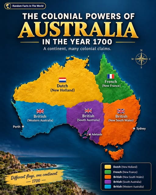
The map in this article illustrates the complicated history of European exploration and territorial claims surrounding Australia. However, it is important to make one distinction: the colorful colonial-style divisions shown in the image should not be interpreted as literal political borders existing across Australia in the year 1700. In reality, European knowledge and claims were developing over time, while Aboriginal and Torres Strait Islander peoples had lived across the continent for tens of thousands of years.
Why Was Australia Called New Holland?
The name New Holland came from the Dutch exploration of the Australian coastline.
In 1606, Dutch navigator Willem Janszoon and the crew of the Duyfken charted part of the western Cape York Peninsula. Over the following decades, Dutch voyages added more sections of Australia’s coastline to European maps.
Dutch ships travelling between Europe and the East Indies sometimes encountered the Australian coast because of their sailing routes and strong winds. These encounters gradually expanded European knowledge of the continent.
The Dutch name New Holland became associated with the landmass that Europeans were beginning to understand as a large southern continent. The name remained in use for a long period, including during the era of British exploration.
The Dutch Were Major Early European Mapmakers
The Dutch played an especially important role in mapping Australia’s coastline during the 17th century.
Explorer Abel Tasman led major voyages in 1642–43 and 1644. His expeditions helped Europeans understand more about the southern Pacific region and Australia’s coastline. He also encountered the island now known as Tasmania, which he named Van Diemen’s Land after Anthony van Diemen, governor-general of the Dutch East Indies.
Other Dutch navigators also recorded sections of the western and northern coastline. Their charts gradually transformed European maps from speculative drawings of an unknown southern land into increasingly recognizable outlines.
This was not a single discovery made on one day. Instead, Australia’s European map emerged through many voyages, observations and corrections over generations.
What Was Australia Like on European Maps Around 1700?
By about 1700, Europeans had substantial knowledge of parts of Australia’s coastline, especially areas explored by Dutch navigators.
But the interior remained largely unknown to Europeans, and the continent was certainly not divided into the modern Australian states.
This is one reason historical maps can sometimes be misleading when viewed through a modern perspective. A map showing different colors does not necessarily mean that clearly defined colonial governments controlled those areas.
European explorers were making observations and, in some cases, territorial claims, but their knowledge of the continent was incomplete.
Meanwhile, Aboriginal peoples had established societies, cultures, languages and connections to Country across the continent for many thousands of years. The European maps represented European geographical knowledge—not the absence of Indigenous ownership or presence.
Where Did the French and British Fit In?
The French and British became increasingly important to the European exploration of Australia later in the 18th century.
British navigator William Dampier visited Australia’s western coast in 1688 and again in 1699, including an expedition to explore and map parts of New Holland.
The most important British mapping expedition came later, in 1770, when Lieutenant James Cook charted the eastern coast aboard HMS Endeavour. Cook claimed the eastern coast for Great Britain and gave it the name New South Wales.
French exploration also became significant during this period. In 1772, François de Saint Aloüarn made a French claim at Shark Bay on the western coast. This occurred decades after 1700 and demonstrates why it would be inaccurate to describe Australia as divided between Dutch, French and British colonial states in that particular year.
The First British Colony Came Much Later
British colonisation was not established in Australia in 1700.
The major turning point came in 1788, when the First Fleet arrived at Sydney Cove and established the British colony of New South Wales. This occurred almost a century after the year shown in the image.
The distinction between exploration, mapping, claiming territory and establishing a permanent colony is important. European ships had visited and mapped sections of the Australian coastline long before Britain established its first permanent settlement.
From New Holland to Australia
The name New Holland remained common for much of the colonial period, but the name Australia gradually became more widely used.
British navigator Matthew Flinders played an important role in this transition. During his early 19th-century voyages, Flinders demonstrated that New Holland and New South Wales were parts of the same continental landmass. He promoted the name Australia, helping establish the term that is now universally familiar.
His circumnavigation also improved European maps of the continent considerably.
This process shows how the map of Australia developed step by step. Dutch voyages revealed important sections of the western and northern coastline. British and French expeditions later added new information, while explorers such as Flinders eventually connected much of the coastline into a more accurate picture of a single continent.
Frequently Asked Questions
Was Australia called New Holland?
Yes. New Holland was the name widely used by Europeans, particularly because of Dutch exploration and mapping of the continent’s coastline. The name remained in use for centuries.
Did Britain control Australia in 1700?
No. Britain had not established its Australian colony in 1700. The first permanent British colony was established at Sydney Cove in 1788.
Who was the first European to map part of Australia?
Dutch navigator Willem Janszoon is generally credited with the first recorded European mapping of part of the Australian coastline, during his 1606 voyage aboard the Duyfken.
When did James Cook explore Australia?
Cook charted Australia’s eastern coastline in 1770, decades after 1700. He claimed the eastern coast for Great Britain and named it New South Wales.
Did Europeans discover an uninhabited Australia?
No. Australia was inhabited by Aboriginal peoples long before European exploration. Archaeological evidence demonstrates the presence of Australia’s First Peoples for at least tens of thousands of years. European maps record European exploration and knowledge, not the beginning of human history on the continent.
Conclusion
The story behind Australia’s early maps is much more complex than a simple division of colored territories.
Around 1700, European knowledge of Australia had been built largely through Dutch voyages and coastal mapping, which helped establish the name New Holland. British and French exploration became increasingly important later, while British colonisation began in 1788.
The modern shape and name of Australia emerged gradually through centuries of exploration, mapping and changing European terminology. Understanding that process also requires remembering that these European maps represented only one perspective: Aboriginal and Torres Strait Islander peoples had longstanding societies and deep connections to the continent long before Europeans arrived.
That makes early maps of Australia valuable historical documents—not simply because they show what Europeans believed they knew, but because they reveal how dramatically geographical knowledge changed over time.