Germany is one of Europe’s most recognizable countries, known for its historic cities, impressive engineering, beautiful countryside, and important role in European affairs. But where exactly is Germany located, which countries surround it, and what does its landscape look like?
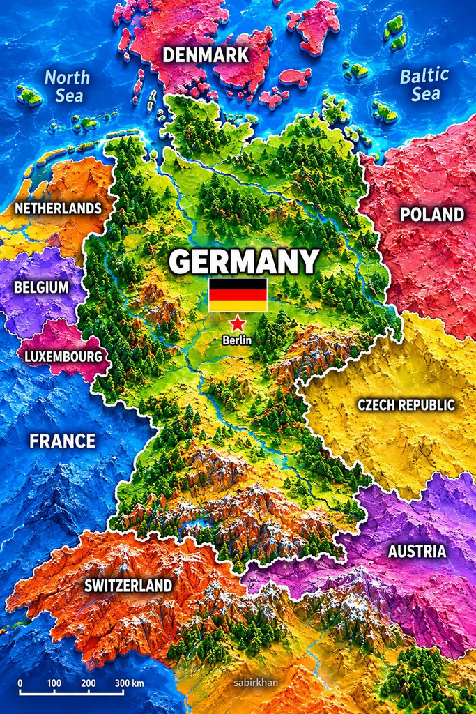
A colorful relief map offers a useful starting point. It highlights Germany in the center, marks Berlin as the capital, and shows neighboring countries in contrasting colors. It also illustrates the country’s varied terrain, from northern lowlands to mountainous regions in the south.
Here is a closer look at Germany’s location, borders, major landscapes, and geographic features.
Where Is Germany Located?
Germany is located in Central Europe, where it connects northern, southern, eastern, and western parts of the continent. Its position makes it an important crossroads for travel, trade, and cultural exchange.
The country covers approximately 357,000 square kilometres, although published area figures can vary slightly depending on the source and measurement method. Germany is a member of the European Union and uses the euro as its currency.
Germany’s capital city is Berlin, located in the northeastern part of the country. Berlin is known for its history, museums, architecture, and cultural attractions.
According to Germany’s official information portal, the country borders nine other nations and has access to both the North Sea and the Baltic Sea in the north. Source: Germany’s official information portal.
Which Countries Border Germany?
One of the most striking facts about Germany’s location is the number of countries it borders. It shares land borders with nine neighbors:
- Denmark to the north
- Poland to the east
- Czechia to the southeast
- Austria to the south
- Switzerland to the southwest
- France to the west
- Luxembourg to the west
- Belgium to the west
- The Netherlands to the northwest
These borders place Germany at the center of a closely connected European region. Several neighboring countries are also members of the European Union, making cross-border travel and cooperation important features of everyday life in the region.
The map uses different colors to distinguish neighboring territories. This is visually helpful, but the artistic shading and raised terrain should not be treated as a precise representation of international boundaries.
For a closer look at Germany’s relationships with its neighbors, see Germany’s nine neighboring countries.
Berlin: Germany’s Capital City
Berlin is marked prominently on the map with a star. As Germany’s capital, it is an important center of government, culture, education, and business.
The city is also a destination for visitors interested in European history. Famous sights include the Brandenburg Gate, the Reichstag building, Museum Island, and the remains of the Berlin Wall.
Berlin’s location in northeastern Germany also helps readers orient themselves when studying the country. It is not in the far north or directly on the coast, but it is relatively close to Poland compared with Germany’s western border regions.
Other major German cities include Hamburg, Munich, Cologne, Frankfurt, Stuttgart, Leipzig, and Dresden. Each has its own character, from Hamburg’s maritime connections to Munich’s proximity to the Bavarian Alps.
Germany’s Landscapes: From Northern Plains to Southern Mountains
Germany’s geography changes considerably from north to south. The colorful relief map emphasizes this variety with green lowlands, forested areas, river valleys, and dramatic-looking mountains.
Northern Germany: Lowlands and Coastlines
Northern Germany includes broad lowland areas and coastal regions along the North Sea and Baltic Sea. The landscape is generally flatter than the mountainous south, although it also contains hills, lakes, and other varied terrain.
The two seas are important features of the country’s geography. Coastal communities have long been connected to shipping, fishing, tourism, and maritime trade.
Central Germany: Forests, Hills, and River Valleys
Central Germany contains uplands, forested areas, and river valleys. The landscape is not a single continuous mountain range; instead, it includes a mixture of hills, basins, plateaus, and cultivated land.
The Black Forest in the southwest is one of the country’s best-known natural regions. Other upland areas include the Harz Mountains and the Bavarian Forest.
These landscapes offer opportunities for hiking, cycling, outdoor recreation, and exploring smaller towns.
Southern Germany: The Bavarian Alps
In the south, the terrain rises toward the Alps, especially in Bavaria near the Austrian border. This region features mountain scenery, lakes, valleys, and popular outdoor destinations.
Germany’s highest mountain is Zugspitze, which rises to about 2,962 metres above sea level. It is located in the Bavarian Alps near the Austrian border.
The mountain relief in the image makes southern Germany appear especially dramatic. However, the illustration exaggerates elevation and color for visual effect; it should not be used to judge actual distances, slopes, or mountain heights.
Germany’s varied natural regions are described in Germany’s official geography and climate overview.
Important Rivers in Germany
Rivers are another major part of Germany’s physical geography. They connect inland regions with cities, agricultural areas, industrial centers, and international waterways.
The Rhine
The Rhine is one of Germany’s best-known rivers. It flows through or alongside several important regions and cities, including areas around Bonn, Cologne, and Düsseldorf. It also forms part of the border between Germany and France.
The river has played an important role in transportation, commerce, settlement, and tourism.
The Danube
The Danube begins in southwestern Germany and flows eastward through several European countries before reaching the Black Sea. It is one of Europe’s major international rivers and connects Germany with a wider network of Central and Southeastern European regions.
The Elbe
The Elbe flows through eastern Germany, linking cities such as Dresden, Magdeburg, and Hamburg before reaching the North Sea. It has historically supported trade and transport between inland areas and the coast.
These rivers help explain why Germany’s location is more than a point on a map: the country is connected to wider European transport routes and neighboring economies.
Why Germany’s Location Matters
Germany’s central European position helps explain its strong connections with neighboring countries. Road and rail networks link German cities with destinations across the continent, while rivers and seaports support freight movement and commerce.
Its geography also contributes to regional differences in tourism and everyday life. Visitors can explore coastal areas in the north, historic cities and forested uplands in central regions, and alpine scenery in the south—all within the same country.
For travelers, understanding the map makes it easier to plan routes and recognize how close many European destinations are to one another. For students, it provides a useful introduction to borders, landforms, waterways, and the relationship between geography and human activity.
Frequently Asked Questions
1. Where is Germany located?
Germany is in Central Europe. It borders nine countries and has coastlines along the North Sea and Baltic Sea.
2. What is the capital of Germany?
Berlin is Germany’s capital. It is a major center for government, culture, history, and tourism.
3. How many countries share a border with Germany?
Germany shares land borders with nine countries: Denmark, Poland, Czechia, Austria, Switzerland, France, Luxembourg, Belgium, and the Netherlands.
4. What is Germany’s highest mountain?
Zugspitze, in the Bavarian Alps, is Germany’s highest mountain, at approximately 2,962 metres above sea level.
5. Is the colorful map accurate for navigation?
No. It is an illustrative relief map designed to make geography visually engaging. For precise borders, distances, routes, or travel planning, use an authoritative geographic map.
Conclusion
Germany’s position in Central Europe gives it a distinctive place on the continent. Its nine neighboring countries, northern coastlines, important rivers, varied uplands, and southern Alpine scenery all contribute to its geographic character.
The colorful map provides an inviting overview, especially for readers learning where Germany is and how it relates to nearby countries. Looking beyond the colors reveals a more detailed story of connected cities, natural regions, waterways, and landscapes.
Whether you are studying geography or planning a European trip, understanding Germany’s location is a useful first step toward exploring the country and the wider region around it.