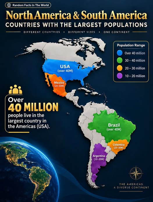
The Americas stretch from the Arctic regions of North America to the southern tip of South America, covering an enormous range of landscapes, cultures, and communities. More than half a billion people live in the countries of North, Central, and South America, but they are not distributed evenly across the continent.
A population map makes that pattern easier to see. The largest concentrations are found in a relatively small group of countries, led by the United States, Brazil, and Mexico. Colombia and Argentina also rank among the most populous countries in the Americas.
There is an important detail to keep in mind, however: population figures change over time, and simplified map graphics can sometimes place countries into outdated or inaccurate categories. Current demographic data gives us a clearer picture.
The United States: The Americas’ Population Leader
The United States is the most populous country in the Americas. The U.S. Census Bureau estimated the country’s population at about 342.6 million on July 1, 2026. Its population is larger than that of any other country in North or South America.
The United States is also geographically diverse. Major population centers include the Northeast, the Great Lakes region, the South, California, and other parts of the West. The country’s large population reflects centuries of natural population growth and immigration.
The United States is also one of only a few countries in the Americas with a population exceeding 300 million.
Brazil: South America’s Population Giant
Brazil is the largest country in South America by both land area and population. World Bank data records Brazil’s 2025 population at approximately 212.8 million.
Brazil’s population is concentrated unevenly across its huge territory. Many of its largest urban areas are located along or relatively close to the Atlantic coast, including São Paulo, Rio de Janeiro, Salvador, Recife, and other major metropolitan regions.
The enormous size of Brazil means that large areas of the country have relatively low population density, while coastal and southeastern regions contain very large urban populations.
Mexico: One of the Americas’ Largest Populations
Mexico is another major population center. According to the World Bank, Mexico had approximately 131.9 million people in 2025. The U.S. Census Bureau’s July 2026 projection placed Mexico at about 132.8 million.
This makes Mexico one of the ten most populous countries in the world and the second-most populous country in the Americas after the United States.
Mexico’s population is concentrated in numerous large cities and metropolitan areas. Mexico City and its surrounding urban region are particularly important, while Guadalajara, Monterrey, Puebla, and other cities contribute to the country’s large urban population.
Colombia and Argentina Add Another Major Population Layer
Colombia and Argentina are also significant population centers in South America.
World Bank data puts Colombia’s 2025 population at approximately 53.4 million, while Argentina’s population was about 45.9 million.
Colombia’s population is strongly influenced by its mountainous geography and major urban centers. Bogotá, Medellín, Cali, and other cities form important population hubs.
Argentina has a different population pattern. A large share of its population is concentrated in and around Buenos Aires and the country’s eastern regions, while vast areas of Patagonia and the far south have much lower population density.
Canada Is Also a Major Population Country
One interesting detail that can be missed when looking at simplified population maps is Canada.
Canada had approximately 41.7 million people in 2025 according to World Bank data.
Although Canada is the second-largest country in the world by land area, much of its territory is sparsely populated because of its northern climate and geography. Most Canadians live relatively close to the country’s southern border with the United States.
This is a useful reminder that land area and population are two very different measurements.
Why Population Maps Can Be Misleading
Population maps are excellent tools for understanding broad demographic patterns, but the categories need to be interpreted carefully.
A country can be enormous yet have a relatively small population. Canada is a clear example. Conversely, a country can have a large population concentrated into a comparatively smaller area.
Population also changes continuously. The U.S. Census Bureau describes its international population figures as estimates and projections, and explains that new demographic information can cause those numbers to change.
This means a map created using one year’s data may look different from a map created several years later.
What the Numbers Tell Us
Using the latest available World Bank 2025 figures, the population ranking among several major countries shown or relevant to the map looks approximately like this:
- United States — 341.8 million
- Brazil — 212.8 million
- Mexico — 131.9 million
- Colombia — 53.4 million
- Argentina — 45.9 million
- Canada — 41.7 million
These figures show why the Americas’ population story is dominated by a handful of countries.
They also show why some simplified color categories in visual maps can become misleading if the underlying data is not updated.
Frequently Asked Questions
Which is the most populous country in the Americas?
The United States is the most populous country in the Americas, with the U.S. Census Bureau estimating roughly 342.6 million people on July 1, 2026.
Which country has the largest population in South America?
Brazil has the largest population in South America. The World Bank reports approximately 212.8 million people in 2025.
Is Mexico more populous than Canada?
Yes. World Bank data lists Mexico at approximately 131.9 million people in 2025, compared with about 41.7 million in Canada.
How many people live in Colombia?
The World Bank reports approximately 53.4 million people in Colombia in 2025.
Why can population maps show different numbers?
Population estimates depend on the year, methodology, census information, birth and death rates, migration, and projections. Different organizations may therefore publish slightly different estimates for the same country and year. The U.S. Census Bureau notes that international population estimates can change as new data becomes available.
Conclusion
The population map of the Americas tells a much bigger story than simply showing which countries have the most people. The United States stands at the top of the regional population ranking, while Brazil and Mexico form two other enormous population centers. Colombia and Argentina are major demographic powers in South America, and Canada demonstrates how a vast land area can coexist with a comparatively smaller population.
The most important lesson is to look beyond the colors on a map and check the data behind them. Population is constantly changing, and accurate comparisons depend on using current and clearly dated estimates.
For anyone interested in geography, these population patterns provide a fascinating way to understand how people are distributed across one of the world’s most diverse regions.