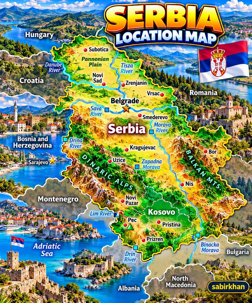
Serbia is a country in southeastern Europe known for its historic cities, beautiful countryside, important rivers, and distinctive position in the Balkans. Although it may be less familiar to some travelers than France, Italy, or Spain, Serbia has a fascinating geography that connects Central Europe with the southeastern part of the continent.
A look at a map of Serbia reveals much more than its borders. It shows the relationship between the Danube River, the northern plains, the central valleys, and the mountainous regions farther south. It also helps explain why Serbia has played an important role in European trade, travel, and history.
So, where exactly is Serbia, which countries surround it, and what should you know about its major cities and landscapes?
Where Is Serbia Located?
Serbia is situated in southeastern Europe, in the central part of the Balkan Peninsula. Its location places it between Central Europe and the southeastern Balkans, making it an important meeting point for different cultures, historical influences, and transportation routes.
Serbia is a landlocked country, meaning it has no coastline of its own. However, major rivers connect its landscapes to wider European waterways, including the Danube, which eventually flows into the Black Sea.
According to the Serbian government’s country profile, Serbia covers approximately 88,499 square kilometres under its stated territorial accounting, which includes Kosovo and Metohija. Figures can differ between sources depending on territorial definitions.
Source: Government of Serbia — Basic Information.
Its capital and largest city is Belgrade, located near the meeting point of the Sava and Danube rivers.
Which Countries Border Serbia?
Serbia shares land borders with several countries, making it an important geographical link within the Balkans.
Its neighboring countries include:
- Hungary to the north.
- Romania to the northeast.
- Bulgaria to the east.
- North Macedonia to the south.
- Croatia to the west.
- Bosnia and Herzegovina to the west.
- Montenegro to the southwest.
- Albania, depending on how the disputed Kosovo boundary is classified in a particular map or source.
Kosovo declared independence in 2008. Serbia continues to regard Kosovo as part of its territory, while many countries recognize Kosovo as an independent state and others do not. This is why political maps may show the boundary and territorial status differently.
For this reason, it is useful to distinguish between a geographical map, which helps locate physical features, and a political map, which reflects particular territorial claims and recognition.
Belgrade: Serbia’s Capital City
Belgrade is one of the most recognizable places on any map of Serbia. Its position at the confluence of the Sava and Danube rivers has helped make it an important centre of transportation, commerce, and settlement for centuries.
The city combines historic landmarks with modern neighborhoods, museums, restaurants, cultural venues, and lively riverside areas.
One major attraction is Belgrade Fortress, located in Kalemegdan Park. The site overlooks the meeting of the two rivers and reflects the city’s long history as a strategic location.
Visitors can also explore Knez Mihailova Street, museums, local markets, and the city’s varied food and nightlife scenes.
Belgrade’s location makes it a natural starting point for exploring Serbia. From the capital, travelers can continue north toward Novi Sad or travel south toward cities and mountain destinations in other parts of the country.
Official travel information: Tourist Organization of Belgrade.
Novi Sad and the Northern Plains
Novi Sad is one of Serbia’s most important cities and the administrative centre of the autonomous province of Vojvodina.
Located along the Danube, the city is known for its cultural life, historic architecture, and access to the surrounding northern plains. Petrovaradin Fortress, which overlooks the river, is among its best-known landmarks.
The wider Vojvodina region is associated with the Pannonian Plain, a broad lowland area extending across several countries in Central and Southeastern Europe.
Compared with Serbia’s mountainous regions, much of the north has relatively flat terrain and extensive agricultural land. These landscapes support farming and help give northern Serbia a different character from the hills and valleys farther south.
Travelers interested in architecture, regional cuisine, and countryside excursions may find Novi Sad and its surrounding areas especially appealing.
More information: Official Novi Sad tourism website.
Serbia’s Major Rivers
Rivers are among the most important features of Serbia’s geography. They influence settlement patterns, agriculture, transportation, and tourism.
The Danube River
The Danube is Serbia’s most significant international waterway. It flows through the country for approximately 588 kilometres, passing important cities and landscapes along its route.
In Belgrade, it meets the Sava River. Farther east, the Danube passes through dramatic scenery associated with the Đerdap Gorge and Đerdap National Park.
The river is also part of a major European navigation network connecting countries across the continent.
The Sava River
The Sava joins the Danube in Belgrade. Its basin connects several parts of southeastern Europe, and the river has long been important for transportation and settlement.
Other Important Rivers
The Tisa, Drina, Velika Morava, and Zapadna Morava are also important geographical features.
Their valleys connect different regions, while the surrounding land supports agriculture, settlements, and local industries.
Official background: Tourist Organization of Serbia — The Danube.
Mountains, Plains, and Natural Landscapes
One of the most interesting aspects of Serbia is the variety of landscapes within a relatively compact area.
Northern Serbia includes fertile plains, while central regions feature rolling hills, valleys, and agricultural areas. Mountainous terrain becomes more prominent toward the west, east, and south.
The Dinaric mountain system influences parts of the western landscape, while other mountain ranges shape the eastern and southeastern regions.
These varied environments create opportunities for hiking, winter sports, nature photography, and rural tourism.
Serbia also has national parks and protected areas. Đerdap National Park, along the Danube, is particularly notable for its river gorge, forested slopes, wildlife, and archaeological heritage.
The contrast between open northern plains and mountainous southern landscapes is one reason a map can be such a useful introduction to the country.
Other Serbian Cities Worth Knowing
Beyond Belgrade and Novi Sad, several cities help explain Serbia’s regional diversity.
Niš is an important city in southern Serbia, with a long history connected to Roman-era settlements and major routes between Europe and the eastern Mediterranean.
Subotica, in the north near the Hungarian border, is known for distinctive architecture and its multicultural regional history.
Kragujevac, in central Serbia, has industrial, educational, and historical significance.
Smederevo, on the Danube, is known for its large medieval fortress.
Each city offers a different perspective on Serbia’s history, economy, culture, and geography.
Is Serbia a Good Destination for Travelers?
Serbia can appeal to visitors interested in city breaks, cultural heritage, local food, outdoor activities, and river landscapes.
A first trip might combine Belgrade’s museums and historic sites with Novi Sad’s architecture and a visit to a mountain or national park.
Travelers should check entry requirements, transport connections, seasonal weather, and local travel advice before planning a visit. Distances and journey times depend on the chosen route and transportation method.
It is also important to remember that Serbia has no coastline. Scenic Adriatic Sea photographs sometimes used in regional travel graphics may depict neighboring coastal countries rather than Serbia itself.
Frequently Asked Questions
1. Where is Serbia on the map of Europe?
Serbia is in southeastern Europe, in the central part of the Balkan Peninsula. It lies south of Hungary and east of Croatia and Bosnia and Herzegovina.
2. What is the capital of Serbia?
Belgrade is Serbia’s capital and largest city. It lies where the Sava and Danube rivers meet.
3. Does Serbia have a coastline?
No. Serbia is landlocked and does not border the Adriatic Sea.
4. What is the longest river in Serbia?
The Danube is the most important major river flowing through Serbia. The Serbian government lists its course through the country as approximately 588 kilometres.
5. Which cities should visitors know about?
Belgrade, Novi Sad, Niš, Subotica, Kragujevac, and Smederevo are among the country’s notable cities. Each has a different historical, cultural, or geographical character.
Conclusion
A map of Serbia provides a useful introduction to a country shaped by rivers, fertile plains, historic cities, and mountain landscapes. Its position in southeastern Europe has connected it with neighboring countries and wider European trade and travel routes for centuries.
From Belgrade’s riverside landmarks to Novi Sad’s cultural attractions and the natural scenery along the Danube, Serbia offers a varied geographical and cultural experience.
Understanding where Serbia is located—and how its rivers, cities, and terrain fit together—is the first step toward appreciating this fascinating part of Europe.